Published on February 12th 2026 | 10 mins , 1966 words
- (a) Give the dates when the sun is overhead along the equator
- \(21^{st}\) March ✓
- \(23^{rd}\) September ✓
(b) State three characteristics of SIAL layer of the earth’s crust
- Rocks are mainly granitic ✓
- The rocks are brittle / ~~rigid~~ on folding they tend to crumble. ✓
- It is lighter / less dense ~~floats on the inner crust.~~ 2.7g/cc
- It floats on SIMA. ✓
- It forms the continental layer. ✓
- It is approximately 70 km thick. ✓
- It is made up of silica and aluminium. ✓
2(a) Explain the term rock as used in Geography?
- It is a natural combination / ~~agglomeration / aggregate~~ of mineral particles that form the solid part of the earth’s crust. ✓✓
(b) List two examples of plutonic rocks
- Granite. ✓
- Diorite ✓
- Gabbro. ✓
- Peridotite ✓
- Syenite. ✓
- Nephline. ✓
3. The following diagram shows a simple fold. Use it to answer question 3(a)
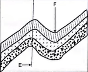
(a) Name the parts ~~marked~~ labelled E and F.
- E-Axis / ~~axial plane~~. ✓
- F-Trough / Syncline / Basin. ✓
(b) Give three factors that influence folding.
- Strength of compressional forces ✓
- Elasticity of rocks / temperatures in the rocks. ✓
- Age of rocks. ✓
- Thickness of the overburden. ✓
- Type of rocks. ✓
4.(a) Identify two ways of measuring the strength of an earthquake
- Intensity. ✓
- Magnitude. ✓
(b) State three natural causes of earthquakes
- Movement of magma within the earth's crust / volcanic eruptions. ✓
- Folding / faulting. ✓
- Isostatic adjustment. ✓
- Energy release within the mantle. ✓
- Divergence / Convergence / Shearing of tectonic plates / ~~Gravitative pressure~~ Tectonic movements. ✓
- Gravitative pressure. ✓
5. (a) Name three soil forming processes
- Weathering. ✓
- Leaching. ✓
- Decomposition. ✓
- Deposition. ✓
1st3×1
(b) Give the three types of soil degeneration.
- Chemical degeneration. ✓
- Physical degeneration. ✓
- Biological degeneration. ✓
6. Study the map of Kipkabus 1:50,000 (sheet ~~no.~~ 104/1) provided and answer the following questions
a(i) What ~~is~~ was the magnetic variation of the area when the map was drawn?
- \(2^{∘}08’ \) ✓
(ii) Name the ~~two~~ types of scales shown on the map.
- Linear scale. ✓
- Ratio scale / RF ✓
(iii) What is the direction of the Air photo principal point 87 in grid square 8338 from the trigonometrical station primary SKP 102?
- North west ✓✓ / \(298^{∘}±2^{∘}\) / \(N62^{∘}W±2^{∘}\)
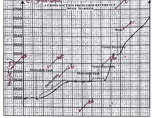
(b) Measure the distance of the dry weather road from grid reference 867365 to 829420. Give your answer in kilometres.
- 7.2 km±0.1 (7.1−7.3) ✓✓
(c) Using a scale of 1cm to represent 20 metres draw a cross-section from grid reference 785320 to 850320. On the cross section, mark and label the following.
- (i) main track (motorable)
- (ii) forest boundary
- (iii) river
- (iv) gentle slope
- There are many permanent rivers. ✓✓
- The main rivers are R. Kimwarer and R. Kiptunoi.
- There are lakes. ✓
- There are seasonal swamps in the west, and south west and north west / west part of the area covered by the map. ✓
- There is papyrus swamp in the western part of the map. ✓
- R. Kimwarer and its tributaries form dendritic pattern, R. Yathine forms trellised pattern. ✓✓
- There are water holes, dams, pond. ✓✓
- Most rivers flow northeastwards. ✓
- Most of the rivers are originating from Keiyo escarpment. ✓
(ii) Citing evidence from the map, explain three economic activities carried out in the area covered by the map
Economic activity and Evidence
Transportation ✓ | Roads / railway line ✓
Trading ✓ | Shops ✓
Wattle cultivation ✓ | Wattle plantation ✓
Milling / Lumbering ✓ | Saw mills / mills ✓
Forestry / Processing ✓ | Forest / forest center ✓
Communication ✓ | Post office ✓
7. Use the map of Africa to answer questions
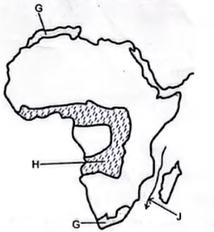
(a) (i) The ocean current marked J
- - (warm) Mozambique ✓ / Agulhas
(ii) The climatic region marked H
- - savanna ✓ / Tropical continental / Sudan type
(b) State the characteristics of the climatic region marked G
- The temperatures range ~~is~~ between 21°C in summer and 10°C in winter. / Summers are warm/hot, winters are cool/mild. ✓
- The mean annual temperature range is between 8°C and 11°C. ✓ / moderate
- Moderate rainfall / 500 mm to 900 mm. ✓
- Rainfall ~~s~~ mainly falls in winter. ✓
- Onshore / Offshore westerlies blow in winter causing cyclonic rainfall ~~cool and wet~~. ✓
- Trade winds are offshore during summer / ~~hot and dry.~~ Summers are dry. ✓
- The area experiences four distinct seasons / spring, autumn, summer and winter. ✓
- Summers have cloudless skies. / Summers have low humidity. ✓
- The western side of the climatic region receives more rain but it decreases inland. ✓
- Has long sunshine duration in summer.
- Experiences foggy conditions along the coast during winter.
- It experiences cold and hot local winds.
7. (c) Explain two ways in which the configuration of the coastline influences climate.
- Irregular / indented coastline has more land area coming into contact with water which maximizes the effect of local wind. Thereby lowering / raising temperatures during the day / night. ✓✓
- Irregular / indented coastline receives more rainfall because prevailing winds blow onshore carrying moisture inland. ✓✓
- Straight / regular coastline receives less rainfall as prevailing winds blow parallel to the coast. ✓✓
- Straight / regular coastline has less land area coming into contact with water which minimizes the effect of local wind ~~thereby rising~~ raising / lowering temperatures during the day / night. ✓✓
(d) Explain how equatorial vegetation is adapted to the climatic conditions
- - Trees have tall / straight trunks to compete for sunlight. ✓✓
- - Trees have broad drip tipped leaves to get rid of excess water due to high rainfall. ~~from the plant.~~ ✓✓
- - Tree trunks have smooth barks with few branches to reduce the amount of water retained due to high rainfall. ✓✓
- - Trees are evergreen because of high rainfall throughout the year. ✓✓
- - The climbers rise to the top canopies to receive sunshine. ✓✓
- - Most trees are hardwood because of constant high rainfall and high temperatures. ✓✓
(e) State four ~~possible~~ pieces of evidence ~~of the~~ for effects of climate change
- Recurrent heat waves in some parts of the world. ✓
- Melting of polar glaciers. ✓
- Receding of ice-cap on Mt. Kilimanjaro / Mt. Kenya / disappearance on Mt. Ruwenzori. ✓
- Increase of rainfall that causes flooding / change in rainfall patterns. ✓
- Disruption of seasons. ✓
- Abnormal plant growth. ✓
- Rise in sea level. ✓
(f) (i) State two objectives of the study
- To find out the factors that favoured the siting of the weather station. ✓
- To find out the instruments found in the weather station. ✓
- To find out how the elements of weather are measured / recorded. ✓
- To find out the significance of data recorded.
(ii) Give four activities that you would undertake in preparation for the study
- Seeking permission from relevant authority. ✓
- Preparing a work schedule. ✓
- Selecting suitable methods of data collection. ✓
- Undertaking a pre-visit / reconnaissance ✓
- Forming groups. ✓
- Formulating objectives / hypothesis
- Obtaining a route map. ✓
- conducting literature review
- Gathering necessary equipment/tools
8. (a) (i) Name two agents of weathering
- Plants ✓
- Animals ✓
- Water / Ice ✓
- Heat ✓
- Air / Gases ✓
(ii) State four types of mechanical weathering
- Block disintegration / Separation
- Exfoliation (Onion peeling / spalling / spheroidal)
- Freezing and thawing / Frost action
- Crystal growth / Crystallization
- Slaking (Wetting and drying)
- Pressure release (Unloading / sheeting)
- Granular disintegration
(b) Describe the process of carbonation
- Rain water dissolves carbon dioxide from the atmosphere to form weak carbonic acid.
- The acidic rain water falls on jointed limestone / calcareous rocks.
- This reaction forms calcium bicarbonate which is soluble / easily disintegrates.
- The limestone rock gradually wears away
c) (i) Give three pieces of evidence of soil creep
- Bending of fences / tree trunks / poles / railway lines.
- Formation of mounds of soil behind walls / base of the slope.
- Tilting of walls.
- Scarp / slope retreat.
- Soil forms terracettes / stepped / ribbed patterns.
- Cracked road
- Existence of bare rock / exposed upper slope.
- Presence of overhanging banks above roads / rivers.
- Rock outcrop arching downhill.
(ii) State four factors responsible for rapid mass wasting.
- Scarcity / absence of vegetation
- Earth movements / earth quakes.
- Unconsolidated / loose materials.
- Steep slopes.
- High rainfall / intermittent supply of water / sporadic downpour.
- Raising temperatures of glaciated highlands.
- Human activities such as quarrying / mining / road construction.
d) Effects of Weathering on the Environment:
- Offers beautiful sceneries for tourist attraction. ✓✓
- Breaks up rocks making mining / quarrying easy. ✓✓
- Leads to formation of minerals (bauxite, aluminium). ✓✓
- Forms the initial stage in the soil forming process. ✓✓
- Weakens rock causing instability in road cuttings. ✓✓
- Accelerates soil erosion. ✓✓
9 (a) (i) Explain the term lake.
- A body of water contained within a crustal basin or hollow / an accumulation of water in a depression or basin.
(ii) Identify three factors that determine the size of a lake -Depth / size of hollow. -Amount of incoming water.
-Amount of water lost through evaporation / seepage through rocks / outflow / Human activities
-Rate of siltation
(b) (i) Apart from crustal warping, give four processes that lead to formation of lakes.
- Faulting
- Folding
- Vulcanicity
- Glaciation
- Deposition
- Solution
- Erosion
- Human activities
- Falling meteorites
- Mass wasting
(ii) State two characteristics of lakes formed through crustal warping
- They are shallow.
- They are large / wide.
- They are formed between two raised land masses.
- They are irregular.
- Most of the lakes have fresh water.
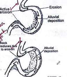
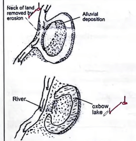
c) With the aid of well labelled diagrams, describe how an ox-bow lake is formed.
- A river at flood plain stage begins to meander
- Intense lateral erosion and undercutting caused by active water currents takes place on its outer (concave) bank while deposition takes place in the inner (convex) bank.
- Due to lateral erosion, there is a reduction of the neck between the bends.
- Continued erosion on the outer bank and deposition in the inner bank makes the meanders to grow outwards.
- The neck of the land between the bends is eventually worn away.
- The two concave banks join causing the river to form a straight channel
- Alluvial deposition on the inner bank seals off the meander and cuts it off from the river
- The abandoned meander forms an ox-bow lake
- It helped to create order during the field study.
- It enabled the students to collect the correct data.
- It enabled all students to participate in the field study.
- It reduced congestion / overcrowding.
- It enabled the students to effectively accomplish their tasks.
- For effective time management.
(ii) Identify three methods of data recording that the students used.
- Photographing.
- Field sketching.
- Notes taking.
- Video taking / Filming
- Filling in questionnaire
10 a (i) Differentiate between porous and pervious rocks.
- Porous rocks have pores / air spaces that allow water to pass through while pervious rocks have cracks / joints through which water infiltrates.
(ii) Explain two ways through which precipitation influences ground water.
- Heavy downpour saturates the soil thus reduces rate of infiltration.
- Light showers that fall over a long period infiltrates more than heavy downpour.
- Very little rainfall merely wets the surface with little / no infiltration.
- High rainfall leads to high rate of infiltration.
(b) State three characteristics of a Karst landscape
- There are numerous solution depressions and residual hills.
- Surface drainage is intermittent or absent.
- There are many steep sided dry valleys.
- Presence of bare, rugged rocks surface / has scanty vegetation.
- Presence of a subterranean network of caverns and water courses.
- Has thin soils.
- The rocks are predominantly limestone / chalk / dolomite.
- Has rugged surface
(c) Explain three ways in which a Karst scenery influences human activities.
- Karst landscapes form beautiful features which attract tourists.
- Limestone landscapes discourage settlement / agriculture due to their ruggedness.
- Solution lakes provide sources of water for domestic / agricultural / industrial use
- Limestone is used as a raw material in iron and steel industry / cement manufacturing.
- The rugged terrain in limestone areas makes it difficult to construct transport lines.
- Limestone rocks are used in building and construction.
- Absence of surface water / vegetation / thin soils discourage agriculture / settlements.
d (i) Describe how the following features are formed I. Swallow hole
- Rainwater dissolves CO2 from the atmosphere to form weak carbonic acid.
- The acid falls on limestone landscape.
- The rainwater reacts with calcium carbonate to form calcium bicarbonate which is soluble.
- The solution dissolves rock minerals widening the joints.
- This widens the joints.
- Continued solution process deepens the joints.
- The deepening and widening forms a vertical shaft / tunnel called a swallow hole.
II. Stalactites
- Drops of water containing calcium bicarbonate seep through crevices and joints of limestone rocks.
- Evaporation takes place because it is warm inside the cave.
- The drops are deposited after evaporation / release of carbon dioxide from the water.
- The drops of calcium bicarbonate then crystallise repeatedly to form hanging finger like projections / pillars on the roof of the cave.
- The hanging fingerlike pillars are called stalactites.
(ii) Apart from stalactites and swallow holes, name two underground features in a Karst scenery
- Stalagmites
- Limestone pillar / column
- Caves / caverns
- Underground / Subterranean streams / rivers